
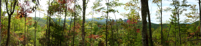
Looking Northeast from Cameron's Ridge Towards the Snowbird Mountains
| Click Here to Return to Cameron's Ridge Home Page |
Cameron's Ridge is a beautiful, nature-friendly, 27.7 acre development by Cameron's Ridge LLC in the forested mountains of southwestern North Carolina within Nantahala National Forest. The land fronts 440 feet along the west side of Hwy 294, a few hundred yards south of the Hiwassee Dam Access Road and about 8.5 miles northwest of the intersection of Hwy 294 and Hwy 64. Thompson Creek runs along the highway, framing the entrance into Cameron's Ridge.
The development began when the property was purchased in September, 2006. During that fall and winter, most of the roads were graded and surfaced with crush rock. Drainage features include rip-rap filled swales emplaced along the roadsides on the upslope sides with culverts placed at intervals under the roads. Three to four inches of asphalt were laid on a crushed gravel road base in August, 2007, following emplacement in July of buried electric utilities (Tristate) and phone lines (Verizon). The pavement width varies from 14 to 16 feet wide with turnouts for passing traffic. Water wells serving one to several residences will be drilled as houses are built.
In the summer of 2007, a small, spring-fed trout pond was dug in the main hollow below a rhodendron grove and marble boulders were placed for landscapping throughout the hollow. Also during this time, stacked stone walls were built across the bridge at Thompson Creek and an electronic gate placed at the highway entrance. A mail kiosk near the gate will be built later after house construction begins.


David Stoessell, a civil engineer in training doing land development in Austin, Texas, provided oversight for the road construction and the lot delineation shown on the plat below. The topography on the plat is from aerial photographs obtained from overflights in late December of 2006. Arville Touchet, former federal soil scientist for the state of Louisiana, took soil profiles on 14 of the proposed lots and these are given in the lot descriptions and will eventually be submitted for septic permits as lots are sold. In general, the soil cover is thick and adequate for septic tank drainage fields.
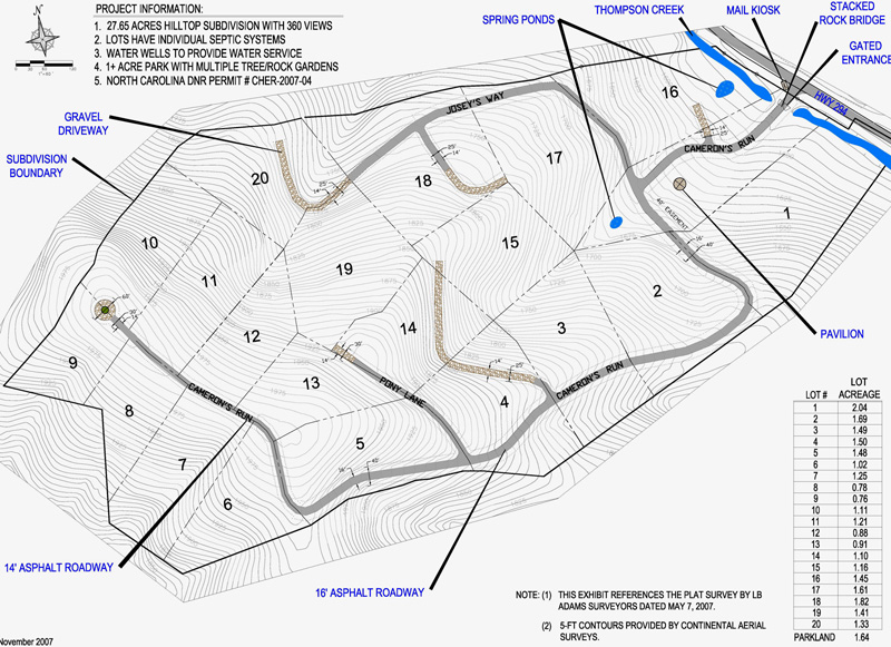
The plot plan has 20 lots (generally 1+ acre each) together with 1.64 acres of common greenspace extending from the road entrance up the hollow to include the pavilion. Nine lots are laid out on the top of the ridge extending downslope, with another eleven lots below on the northeast side of the ridge. The large lots are designed around natural house sites so that clearing for a lawn and a mountain view can still leave woods for privacy, natural beauty and wildlife habitat. Wildlife easements along the lower lot boundaries will protect the privacy of home sites by preserving woods. However, most homeowners will leave additional forested areas because they do not want to maintain a large lawn on a mountain slope and they want a view of trees, rather than neighboring homes. Our objective is to complement the beauty of the natural environment on Cameron's Ridge with beautiful homes that blend into the environment.
In the winter of 2007, the decision was made to put the Development on Hold until the current recession is over. The remaining projects to be completed are obtaining the septic tank permits for individual lots and drilling water wells.
Londi Moore is a licensed North Carolina builder with Nature's Escapes and may supervise the building of houses in the development. Lots will be sold to individuals who can use their own builder with an approved building plan. If you are interested in purchasing a lot, "spec" house, or having a custom house built, please contact her at 985-705-1606.
Ron Stoessell and Londi Moore set up Cameron's Ridge LLC to develop Cameron's Ridge and other properties while maintaining wildlife habitat and enhancing the natural beauty of the North Carolina forests. As the development of Cameron's Ridge proceeds, this web page will be updated with pictures and further information.